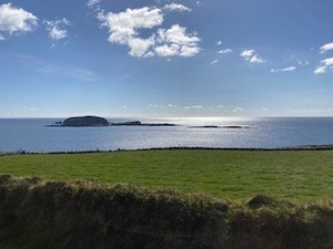
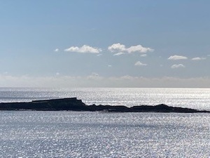
An tOileán Íseal or Low Island is a townland of c. 2 hectares/ 4 acres and in the early part of the 19th century no individual fields were mapped in this townland. It lies just northwest of An tOileán Ard and the two islands are separated by a channel known as Siúnta na Greidhrice. The islands are c. 2.5km offshore if one boats or kayaks across from the mainland.
It is in the Electoral Division of Myross, in Civil Parish of Myross and the Roman Catholic Parish of Castlehaven and Myross.
An tOileán Íseal is not surrounded by any townlands.
OpenStreetmap contributors, with input from the Castlehaven & Myross History Society, have created a detailed townland map including all its minor placenames. Zoom in for further detail.
Etymology
An tOileán Íseal can be interpreted as the island that is low. It was also know as Oileán na nUan (lambs) as it was used for summer grazing of sheep (and/or goats). (check with Denis). Ára Theas (Southern Ára or southern church/altar) is another old name for the island. Bruno O'Donoghue interprets Ára Theas as the southern tract.
Low Island is the English translation of an tOileán Íseal and the first reference was in 1618 when the Calendar of Patent Rolls of James I mentioned 'the two islands called the High and Low Islands in Clancahill'. Both islands are approrriately named.
History
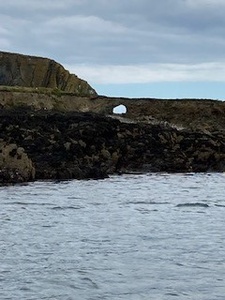
Storm Ophelia: The topography of Low Island was changed by Storm Ophelia in 2017. Part of the southern face was blown away, creating a big gap and a circular hole, which can be seen from the western end.
Copper Rock: A ship laden with maize, the Margaret Nolan, was stranded and wrecked in 1891 at Copper Rock, a rock submerged at low tide, a little to the west of High Island. This rock was known as Gaeilge as Carraig a' Phráis (meaning 'brass rock').
Housing
There is no history of any housing in this townland
Places of Interest
Graveyard: There is a graveyard on an eroded neck of land at south side of Low Island named 'Old Grave Yard' on OS 6-inch map (1842) and 'Burial Ground (disused)' on the OS 25 inch. It is also the site of a possible mortuary chapel (CO151-043002-). The earliest known Church in the Parish of Myross was built on Low Island or Ára Theas/Arahas and in time this island was one of the chief burying places in Corcalee for people from the mainland. It preceded the church in Myross Island. Source Historic Graves
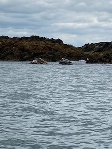
Carraig a' Róin: This can be interpreted as seal rock and lies west of Low Island and is a place frequented by seals to this day.
Capaillín: This is a fishing mark so called because of its supposedly pony-like appearance
Fowl Island: This is situated south-west of Low Island
Tráigh an Teampaill: This can be interpreted as the strand of the church. It lies on the north side of Low Island and was the point of embarkation for the mainland while a small landing point to the east of Myross graveyard phonetically known as the Modré was the departure point.
Interesting Placenames
No field names have been captured on this island
If you know any other field names or placenames on this island (or if you need to correct any or give further background information), please contact us at [email protected]
Folklore
Myross Poem: According to Lankford an old poem about Myross refers to the following:
Baile na Tóna agus paróiste Mhiodhruis
Meall Uí Chorráin agus dá Rinn theas
An t-Oileán Árd agus an t-Oileán Íseal
Oileán Molua agus Oileán Brighde
(Ballinatona and the parish of Myross, Maulicarrane and the two South Reens, High Island and Low Island, Horse Island and Rabbit Island)
Families and Notable Residents
The Tithe Applotment books of 1829 list the following family names: None
Griffiths Valuation of 1853 lists the following family names: Dinneen, Driscoll. Note: Wm Dinneen and Florence Driscoll rented the land but were not resident. The Island was most likely used for summer grazing or perhaps for potatoes. These men also rented High Island.
The Census of Ireland of 1901 lists the following family names: None
The Census of Ireland of 1911 lists the following family names: None
Demographics and Landholding
| *Occupiers | Population | Change | Link to record | ||
| 1825 | Tithe Applotment | 0 | 0 | Not listed | |
| 1841 | Census of Ireland | 0 | 0 | ||
| 1851 | Census of Ireland |
0 |
0 | ||
| 1853 | Griffith's Valuation |
2 landholders
|
0 | 1853 | |
| 1861 | Census of Ireland | 0 | 0 | ||
| 1871 | Census of Ireland | 0 | 0 | ||
| 1881 | Census of Ireland | 0 | 0 | ||
| 1891 | Census of Ireland | 0 | 0 | ||
| 1901 | Census of Ireland | 0 | 0 | Not listed | |
| 1911 | Census of Ireland | 0 | 0 | Not listed |
*Occupiers generally equate to households having a house and land but may also include households having houses but no land.
Between 1656 and 1658 the Down Survey mapped all areas of the country to track ownership of land after much had been granted to followers of Cromwell after the war of the 1650's. No proprietor in this townland in mentioned in the Down Survey (1656-1658).
The proprietor in 1841 was Edward Powell (Major Powell of Bawnlahan House, Myross who was connected through marriage to the O'Donovan family). It was let at that time to Daniel O'Donovan of Rosscarbery for grazing. As it was not inhabited, it was not subject to a County Cess or a tithe.
No description of soil quality in 1841 was given
Images
 High and Low Island from Myross Graveyard
Further Reading
-
Parish Histories and Placenames of West Cork - Bruno O'Donoghue
- Exploring West Cork by Jack Roberts, Key Books, 1986.
-
Placenames Database of Ireland Logainm.ie entry for statutory version in Irish and English
- A Collection Of Placenames From Cork County, Barony Of West Carbery (East Div.),Volume 6 - Dr Éamon Lankford
- Castlehaven & Myross History Society Journal Vol. 1 - 2020
- Castlehaven & Myross History Society Journal Vol. 2 - 2021
- Castlehaven & Myross History Society Journal Vol. 3 - 2022
- Parish Histories and Place Names of West Cork - Bruno O'Donoghue
- See townlands.ie for information on this townland
Links
Go to Homepage
Go to list of Townlands
Go to list of Irish words used locally
Go to local Flora and Fauna


