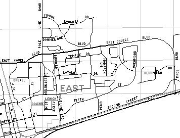
East Davis is officially defined as "north of I-80, east of J Street and north of East 8th Street." In other words, it's everything north of I-80 and east Of J Street except for the square bounded by East 8th, J Street, I-80, and Pole Line. This square is part of Downtown Davis.
Informally, most people referring to "East Davis" are talking about anything east of the railroad tracks, and north of I-80. Bob Dunning likes to refer to the section of town immediately east of the tracks, south of Fifth, and ending at L Street as "Olde East Davis" while others call it The People's Republic of East Davis. That makes downtown the traditional square bounded by B to the west and H to the east, Fifth to the north, and First to the south. Historically, the actual downtown comprised G Street from Second to Fourth, and Second from F to G. The rest of the area between that and the university was primarily residential until during the 50s and 60s. "Old East Davis" is an area of Davis recognized by the city council, interested developers, and the Old East Davis Neighborhood Association. Additionally, there's a section of town recognized as Old North Davis.
Many UCD students live in East Davis because of cheaper apartments and houses. Non-students (read: real adults) can afford more luxurious abodes, so they live in the Mace Ranch and Wildhorse developments. East Davis is also home to 5 schools: Korematsu Elementary School, Birch Lane Elementary School, Holmes Junior High School, Harper Junior High School, and DaVinci High School.
Animal lovers are welcome too! The Toad Hollow Dog Park is a great place to take your furry best friend, or you can walk your pooch on the 3 greenbelts. And there's a Burrowing Owl Reserve. Owl's gotta live, man.
See Navigating Davis for other regions.
Parks/Public Facilities
 Traditionally, East Davis is defined by the railroad tracks
- Chestnut Park
- Davis Cemetery
- Davis Community Garden
- Green Meadows Greenbelt
- Mace Ranch Greenbelt
- Mace Ranch Park
- N Street Park
- Nugget Fields
- Sandy Motley Park
- Slide Hill Park
- Toad Hollow Dog Park
- Wildhorse Greenbelt
Food
- Carl's Jr.
- Cenario's Pizza
- Jade Garden
- Little Caesars Pizza
- Ikedas
- Konditorei
- Nobu Hiro
- Nugget - Sandwiches, Chinese, Coffee drinks, Smoothies, Deli Food (the Mace/Chiles @ Cowell location is more east than the Pole Line/Covell location)
- Pink Dozen
- Pizza Guys
- Red Orchid
- Stone's Cafe & Catering
- Subway
- Sudwerk
- Symposium
- Taqueria Davis
- Tutti Frutti Frozen Yogurt
- Wildhorse Grill
Businesses
a partial list
- Automotive
- City Services
- Clothing and Fabric
- Food and Beverage
- R&D
- Sports and Fitness
- Miscellaneous
See also Davisville Professional Center for more.
Shopping Centers
Housing
- Alhambra Apartments [4500 Alhambra Drive (530) 297-7368)]
- Cambridge House Apartments [619 Pole Line Road (530)756-4020]
- Cascade Apartments [771 Pole Line Road (530)758-4601]
- Chestnut Place Apartments [1615 E 8th Street (530)753-0695]
- Cranbrook Apartments [955 Cranbrook Court (530)756-9522]
- Crescent Villa Apartments [30 Simmons Way, 1455-1477 East 8th Street (530)756-6760]
- College Square Apartments [801 J Street (530)756-2654]
- Davisville Apartments [1221 Kennedy Place (530)756-2311]
- Eighth Street Apartments [1521 E 8th Street 530)758-2261]
- Eleanor Roosevelt Circle [675 Cantrill (530)753-3400] *senior affordable units
- Fifth Avenue Place [500 Pole Line Road (530)758-3240]
- Greystone Apartments [2505 5th Street (530)758-2200]
- Ikkyu Apartments [1805 East 8th Street]
- J Street Apartments [1111 J Street (530)756-2100]
- J Street Co-op
- Lanai Garden Apartments [1841 East 8th Street (530)753-5025]
- Moore Village [2444 Moore Boulevard]
- N Street Cohousing
- Pennsylvania Place Apartments [911 Pennsylvania Place (530)756-3355]
- Pinecrest Apartments [920 Cranbrook Court (530)756-9550]
- Regency Arms Townhouses Apartments [30 Simmons Way (530)756-6760]
- Seville at Mace Ranch Apartments [4501 Alhambra Drive (530)297-1200]
- Silverstone [2400 Pole Line Road (530)758-5505]
- Terracina Apartments [1800 Moore Boulevard (530)758-1267]
- Tuscany Villas Apartments [2526 E 8th Street (530)757-4443] (affordable housing units available)
- University Village [625 Cantrill Drive (530)753-2440
- Villa Calabria [2537 East Eighth Street (530)757-4443] *senior affordable units
- Wildhorse Condominiums [1818 Moore Boulevard]
- Windmere Apartments [3030-3100 Fifth Street (530)757-4438]
Neighborhoods
- Covell Village - Proposed housing/commercial development
- Davis Manor
- Mace Ranch
- McKeon Condominiums
- Rancho Yolo - Senior mobile home park
- Wildhorse
Toad Tunnels


