An Scoth Bhán or Scobaun is a townland of 76 hectares or 189 acres and in the early part of the 20th century, 116 individual fields were mapped in this townland.
It is in the Electoral Division of Castlehaven South, in Civil Parish of Castlehaven and the Roman Catholic Parish of Castlehaven and Myross.
An Scoth Bhán is bordered by Baile Uí Chatháin (Ballycahane) to the east and An Gort Breac (Gortbrack) to the north, An Dúinín (Dooneen) to the west and Fearann Uí Chonchúir (Farranconnor) to the south
OpenStreetmap contributors, with input from the Castlehaven & Myross History Society, have created a detailed townland map including all its minor placenames. Zoom in for futher detail.
Etymology
An Scoth Bhán was interpreted by Bruno O'Donoghue as the white reef. While J.M. Burke agrees with this in his 1913 Southern Star article, he offers an alternative as the white flower. Other interpretations are the fine grassland or the white point. The white reef is possibly the most plausible interpretation in view of the presence of a shallow reef a few metres off-shore over which the sea breaks in most weathers resulting in white breaking waves.
The lios/ringfort called Lisnacaheraghmore which gets its name from Lios na Cathrach Móire was interpreted by Bruno O'Donoghue as the fort of the big mansion. Perhaps the large stone ringfort would be a more accurate translation.
The fort called Port 'a Dúna was interpreted by Bruno O'Donoghue as the landing place of the fortress.
History.
Patent Rolls: The Calendar of Patent Rolls of James I (page 288) provides the first documented reference to the townland when it was recorded as Scoghbane in 1615. The Down Survey maps of 1654-56 record the name as Scubane. The name of the townland is quite consistent in historical records from the 17th century onwards.
School: Dooneen School is believed to have been the first school in the parish when it opened in 1845. The teachers at the time of Griffiths Valuation (1853) were listed as Charles Calnan and Honoria Leary. A refurbished school was opened in 1935 and this was closed around 1966. An interesting fact is that evening classes were organised at the turn of the 20th century which were designed to improve the English of male students. Other subjects were taught to equip the students for emigration or perhaps for a job with the British navy. The teachers who taught pupils in the evening were different from those who taught during the daytime. At that time, the evening teachers were Jeremiah O'Regan and Daniel Donovan.
 Roll Book Dooneen School 1903-1904
Irish Speakers: It is recorded in the 1911 census that the last two monoglot Irish speakers (spoke Irish only) in the parish lived in Scobaun at the time. Their names were John Sexton, a widower, and Mary O'Sullivan, a widow, who were possibly brother and sister-in-law. He was 78 at the time of the 1911 census and she was 90 and they were both illiterate.
Housing
As part of Griffiths Valuation in 1853, a survey of house quality was carried out to calculate what rates were due by each household. These were issued in 1850 in the form of house books (Pg 1, Pg 2) and a guide on how to interpret these can be seen here. These show that 13 of the 16 houses in the townland at that time were class 3. This means that they were thatched houses with stone walls with mud or puddle mortar. Five are described as being old (more than 25 years) but in good repair while three were old but out of repair. Five class 3 houses were of medium age (two slightly decayed, but in good repair while the other three were deteriorated by age and not in perfect repair). The other three houses in Scobaun at this time are class 1 which means that they were slated and built with stone or brick and lime mortar - one was described as being medium, slightly decayed but in good repair while the other two were described as an ordinary finish. All houses in the townland at this time are between 6 foot and 8 foot tall which indicates that they are single-storey at this time.
By the 1901 census, there is a reduction to 12 occupied houses in this townland and all had walls of stone, brick or concrete. Four of the houses have roofs of slate, iron or tiles while the other eight are still thatched. All four with roofs of slate, iron or tiles have two, three or four rooms bar one which only had one room. Two houses have just one window in front while a further nine houses have just two windows in front which indicate that they are probably still single storey at this time. The remaining house has five windows in front.
When we advance to the 1911 census there are still 12 occupied houses in this townland and, not surprisingly, all still have walls of stone, brick or concrete. Six houses now have roofs of slate, iron or tiles while the other six are still thatched. Two houses are now listed as having just one room (there was one in 1901) and the other ten houses still have two, three or four rooms. Two houses still have just one window in front while seven houses have two windows in front which indicate that they are probably still single storey at this time. There are now three houses that have five windows in front.
Places of Interest
Lios: There are three ringforts (liosanna) in this townland (two of which are mapped). A ringfort is a circular fortified settlement that were mainly built during the Bronze age up to about the year 1000. A large circular ringfort called Lios na Cathrach Móire (Liosnacaheramore) stood on elevated ground at the northern end of the townland until the mid 19th century. No trace remains of this fort. As a 'cathair', it may have been a stone fort rather than an earthen fort. The stones may have been used for road or house building.
Fort: Port a' Dúna is a promontory coastal fort, probably originally iron-age. It is now badly eroded on the coastal side and is situated at the southern end of the townland. It is said to have been occupied by sea-raiders (pirates) and later by the Coast Guard. The name 'port' suggests that there may originally have been a landing place below the fort. The fort was excavated by Professor O'Kelly of UCC Archaeology Department in the 1940s.
Tobar an Ime: A well on the eastern boundary of Scobaun (with Ballycahane) is known as Tobar an Ime (the well of the butter). It is not a holy well. The origin of its name is unknown.
Gap na gCorp was a spot on the coast road just east of the junction of the boreen up to Scobane and Ballycahane where it was said that funeral parties would pause on the way to Castlehaven Old Cemetery. It is also an interesting example of a placename as it contains a mixture of two languages. It has been suggested that the correct name for this spot may actually be Geata na gCorp (gate of the corpses).
School: There was a National School in this townland. However it was named Dooneen National School - sometimes known as Scoil Bearcháin Naofa.
There are a number of sites listed in this townland in the Historic Environment Viewer. As well as the fort mentioned above, there is also an enclosure and a souterrain mapped. The souterrain was at the same location as Liosnacaheramore and no trace of either remains today
Interesting Placenames
Besides the places named above, there is a field named the Scobaun House Field. According to Lankford, there was a house here that was used by the Somervilles for retreats but it fell into disrepair and was knocked. However some local sources doubt the accuracy of this entry as there is no memory of such a house ever having existed. There is also a coastal inlet called Poll Gorm - this can be interpreted as the blue hole. There is a cove that sits on the boder between Ballycahane and Scobaun. This is known as Cuas an tSrutháin which can be interpreted as the cove of the stream. The road called The New Line touches this townland and there was a boreen called An Boreen Dearg (red boreen) which was a rough track that is no longer visible.
Other old field names in this townland have been captured as follows: The North Meadow, The Middle Meadow, The South Meadow, Páirc a' Lathraigh/Páirc i Lár (A field of muddy ground / the field of the mare / the middle field), Páirc a’ Choirce (the field of oats), The North Linga (unknown - maybe a meadow field along a stream), The South Linga (unknown), Páircín (small field), An Clós (paddock), Garraí Eoin (Garryowen - Eoin's garden), Upper Páirc an Sparraig (unknown), Lower Páirc an Sparraig (unknown), Upper Páirc Uí Néill (O'Neills Field), Lower Páirc Uí Néill (O'Neills Field), Cross Field, The Lios Field (fort), The Cross Field, The Quarry Field.
If you want to see the actual locations of any of these, go to detailed townland map on Open Street Maps. If you know any other field names or placenames in this townland (or if you need to correct any or give further background information), please contact us at [email protected]
Folklore etc
Páirceanna Caillte na Scotha Báine The Lost Fields of Scobaun
le Mícheál Ó Seasnáin Michael Sexton
Móinéar glas fairsing ag síneadh amach romham An expanse of green meadow stretches before me
Le fána na leacan go habhainn bheag mhín; Down the slope of the field to a small, gentle stream;
Ollghort gan claíocha, gan foscadh, gan teorainn, A prairie without ditches, without shelter, without boundaries,
Scartha ón dtig inar chónaigh mo shínsir. Cleaved from the house where my forebears once lived.
Níl trácht ar an Linga nó ar Pháircín a’ Sparraigh There’s no mention of the Linga or of Páircín a’ Sparraigh
Agus scriosta ó chóiriú Páirc a’ Choirce faraor; And Páirc a’ Choice alas is ruined beyond mending;
Ni luaitear Páirc Lárach, an Clós ná an Cumar You won’t hear of Páirc Lárach, the Clós or the Cumar;
Is ní chuimhnítear ar dhaoine gan trácht ar gharraí. The people forgotten not to mind names of fields.
Ní chloistear an crotach nó Síle na bPortach No cry of the curlew or the bog-loving heron
Agus is tostach an Ghaolainn le géimneach bó riabhaigh; And our language as silent as the brindle cow’s lowing;
Níl cloch ina seasamh ar Lios na Cathrach Móire There’s no stone left standing on Lios na Cathrach Móire
Is ní olfar braon choíche ó Thobar an Ime. And no thirst to be quenched at the Tobar an Ime.
Do shiúileas an lom seo le m’athair tráthnóna, I walked through this wasteland with my father one evening,
An ghrian ag fuineadh ar a shaol is ar tír. As the sun was declining on his life and the land.
Do mheabhraigh sé ar Thuamaigh, Súileabhánaigh is Coileánaigh He brought to mind Murphys, Sullivans and Collinses
Is ar ár ndream féin, Seasnánaigh, uile scaipthe leis na claíocha. And our own crowd, the Sextons – all now scattered like the ditches.
Anamacha ‘mithe ar shlí naofa na firinne, As their souls have departed to their eternal rewardings,
Logainmneacha caite mar anáil bhog gaoithe. Their placenames have vanished like the soft breath of wind.
Mar níl ach seal gairid i ngach rud a chrothaítear There’s only a short spell in all that’s created
Idir cuimhne is daoine is móinéar is claí. Whether memory or people or meadow or ditch.
Families and Notable Residents
The Tithe Applotment books of 1825 (where the townland is transcribed as 'Skubbane') list the following family names: Sexton, Sullivan, Hourahane, Hourahane, Henry, Henry, Henry, Driscoll, Sexton, Sullivan, Sullivan, Henry.
Griffiths Valuation of 1853 lists the following family names: Hourihan, Sullivan, Sullivan, Hourihan, Hourihan, Sexton, Sexton, Leary & Calnan (both teachers at Dooneen National School), Sexton, Driscoll, Sullivan, Leary, Hourihane, Foley. In addition, the following families leased land only: Murphy
The Census of Ireland of 1901 (where the townland is incorrectly transcribed as 'Seobane') lists the following family names: Sexton (with Collins (wife)), Sullivan, Collins (with Hallihane (grandson)), Horan, Hourihane, Sullivan, Hourihane, Sexton (with Sullivan (sister-in-law)), Hourahine, Murphy, Twomy, Twomey (with Donoughue (grandson))
The Census of Ireland of 1911 lists the following family names: Sullivan, Horan, Collins, Collins, Sexton, Sexton (with Sullivan (relative)), Hourihane, Sullivan, Hourihane, Murphy, Hourihane, Twomey
Note: the term 'with' refers to a person or persons of a different family name staying in the house. This may have been an in-law or other relative, a guest, or a farm labourer/housekeeper or domestic servant.
Demographics and Landholding
| *Occupiers | Population | Change | Link to record | ||||||
| 1825 | Tithe Applotment | 12 | 75 est | 1825 | |||||
| 1841 | Census of Ireland | 19 | 113 | ||||||
| 1851 | Census of Ireland | 13 | 82 | ||||||
| 1853 | Griffith's Valuation |
14 |
85 est | 1853 |
|
||||
| 1861 | Census of Ireland | 16 | 99 | ||||||
| 1871 | Census of Ireland | 14 | 97 | ||||||
| 1881 | Census of Ireland | 14 | 85? (difficult to read) | ||||||
| 1891 | Census of Ireland | 14 (incl. 2 unoccupied) | 68 | ||||||
| 1901 | Census of Ireland | 13 | 62 | 1901 | |||||
| 1911 | Census of Ireland | 12 | 54 | 1911 |
*Occupiers generally equate to households having a house and land but may also include households having houses but no land.
Between 1656 and 1658 the Down Survey mapped all areas of the country to track ownership of land after much had been granted to followers of Cromwell after the war of the 1650's. The most prominent proprietor (titulado) of this townland at that time (1656 - 1658) was Charles McCarthy Reagh, Irish Papist. This townland was part of Downeing & Scubane at that time.
The proprietor of this townland in 1841 was Sampson T. French of Cobh and his agent was Gilbert Ross of Smorane, Skibbereen. It was all held by tenants without a lease.
In 1841, the soil was described as middling, producing light crops of oats, wheat, a little flax and middling potatoes.
Images
 Port a' Dúna (Portadoona) Promontory Fort (circular-looking mound in middle distance)
 Lios (ringfort) at Scobaun looking north. (400m east of former schoolhouse on south side of road)
 Lios (ringfort) at Scobaun looking north-east
 Sexton family c 1960
 Group photo taken at an 'American Wake' in Connie Leary's house as his sister left for the US (includes Corny Savage, Pat Cahalane, John Patrick Collins (Tracarta))
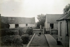 Scobaun farmhouse (Sextons) 1960s (looking west)
.jpg/_info/)
 Jeremiah Murphy and wife Mary (nee Sexton) in traditional West Cork Cloak
Jeremiah Murphy and wife Mary (nee Sexton) in traditional West Cork Cloak
 Dooneen NS children c. 1925 (the school is situated in the townland of Scobaun)
 Dooneen NS children c.1928
 Dooneen NS girls c.1930
 Grave of Cornelius Sexton, Scobaun (Irish Guards), at Lijssenhoek, Belgium. Killed at Ypres, 23 July 1916
Further Reading
-
Parish Histories and Placenames of West Cork - Bruno O'Donoghue
-
Placenames Database of Ireland Logainm.ie entry for statutory version in Irish and English
- A Collection Of Placenames From Cork County, Barony Of West Carbery (East Div.),Volume 2 - Dr Éamon Lankford
- Castlehaven & Myross History Society Journal Vol. 1 - 2020
- Castlehaven & Myross History Society Journal Vol. 2 - 2021
- Castlehaven & Myross History Society Journal Vol. 3 - 2022: Recollections of Life in Scobaun in the 1940s and 50s - Neilie Sexton
- Castlehaven & Myross History Society Journal Vol. 3 - 2022: Páirceanna Caillte na Scotha Báine - Mícheál Ó Seasnáin
- Parish Histories and Place Names of West Cork - Bruno O'Donoghue
- Local Names - JM Burke (J.M.B) - Southern Star - 4th October 1913
- See townlands.ie for information on this townland
Links
Go to Homepage
Go to list of Townlands
Go to list of Irish words used locally
Go to local Flora and Fauna

