An Bán Leathan or Bawnlahan is a townland of 75 hectares or 185 acres and in the early part of the 20th century, 79 individual fields were mapped in this townland.
It is in the Electoral Division of Castlehaven South, in Civil Parish of Castlehaven and the Roman Catholic Parish of Castlehaven and Myross.
An Bán Leathan is bordered by Ard an Ghiolla (Ardagilla) and An Driseán Beag (Drishanebeg) to the west, Gleann an Gheimhil (Glannageel) to the north, Barraí Rua (Barryroe) and Rinn Dá Chosán (Reendacussane) to the east, and Geocán (Gokane) to the south.
OpenStreetmap contributors, with input from the Castlehaven & Myross History Society, have created a detailed townland map including all its minor placenames. Zoom in for further detail.
Etymology
An Bán Leathan can be interpreted as the wide pasture or alternatively as the broad (cattle) enclosure (Bádhún Leathan). The latter is also the interpretation given by Bruno O'Donoghue. In his article in Volume 7 of the Skibbereen and District Historical Society Journal, Eugene Daly agrees with the interpretation of a broad enclosure or field.
History
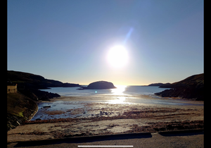 The trá at Tragumna with Drishane Island in the centre.
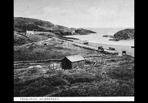
School: Not many would believe you if you said there was a primary school in the car park at Tragumna. Maybe the fact that the road to both Baltimore and Skibbereen passed this way affected the location. About 1891 a lovely school (actually situated in the neighbouring townland of Drishanebeg) welcomed boys and girls from neighbouring townlands, even if they didn’t want to go there. It was only in 1912 that the road across the beach was made permanent. There was a little one eyed bridge where water flowed in and panniers of sand sailed out, contrary to the newly introduced laws. The school was located close to the site of the present public toilets. Many teachers plied their trade in that edifying building . Outside the entire area was a mass of grass with heaps of sand and seaweed salvaged from the sea.
Perhaps there were happy pupils when the sea claimed the school after a severe storm in 1942. It was probably utopian till a house was converted, halfway up the hill. Finally the new school opened in 1946 and continued service until 1990. Many of these displaced students comment that they received third level education in Tragumna, first level on the beach followed by second level in Driscolls ?? And finally third level in the new school. There was an older school somewhere in the townland of Drishanemore along with hedge schools. One of the closest was at Kilderry. A wall from this school still stands and the teacher was recorded as John O Brien.
Kidnap: On Sunday,July 10th. 1921 Eddie Swanton was returning with friends from a days bathing in Tragumna when he was unceremoniously abducted by local rebels. They seized a number of horses and carts and one motor. He was a magistrate and according to himself he was well treated by his captors. He was even allowed to send home a note on the clothing he needed. Eventually he escaped and fled to England. However his fathers shop in Skibbereen was targeted by disgruntled Republicans. Many decided to boycott the business and defaulted on payment of bills.
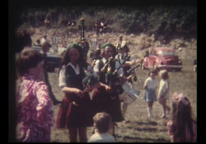
Music and Dance: Tragumna Pipe Band operated during the 1970s. Regattas were held in Tragumna as far back as 1898 .At the same time athletic races were run off. Now a days the annual threshing and charity walk are major fundraisers for good causes.trim.717A8AC3-445F-4F2B-9CC7-941A28C37DC1.MOV
A pattern dance took place at Tragumna around the middle of the last century at a location opposite the local pub. There is documentary evidence of a pattern near the strand as far back as 1885.
Shops: There were, at various times, four separate shops in Bawnlahan: O'Mahony's in Tragumna, Joe McCarthy's was opposite the current Skibbereen Eagle public house; Jerry Hegarty's was on the corner close to the new slipway at An Cúl Tráigh or 'back-strand'; and there was also what appears to be what might now be known as a 'pop-up' shop.
Housing
As part of Griffiths Valuation in 1853, a survey of house quality was carried out to calculate what rates were due by each household. These were issued in 1850 in the form of house books and a guide on how to interpret these can be seen here. These show that 10 of the 11 houses in the townland at that time were class 3. This means that they were thatched houses with stone walls with mud or puddle mortar. Five are described as being old (more than 25 years) but in good repair while the other five are also old but out of repair. The other house in Bawnlahan at this time is class 1 which means that it was slated and built with stone or brick and lime mortar - it was described as being medium, slightly decayed, but in good repair. All houses in the townland at this time are between 5 foot (!) and 8 foot tall which indicates that they are single storey at this time.
By the 1901 census, all eleven occupied houses have walls of stone, brick or concrete. Seven of the houses have roofs of slate, iron or tiles while the other four are still thatched. All four have two, three or four rooms. One house has just one window in front while eight houses have just two windows in front which indicate that they are probably still single storey at this time. The other two houses have five windows in front each.
When we advance to the 1911 census there are now 10 occupied houses in this townland. However only nine houses have walls of stone, brick or concrete while the other has walls of mud, wood or other perishable material. Similarly seven houses have roofs of slate, iron or tiles.while the other three are thatched. All ten houses have two, three or four rooms. One house has just one window in front while six houses have just two windows in front which indicate that they are probably still single storey at this time. One house has four windows and the other two houses have five windows in front each.
Places of Interest
Tragumna: This can be interpreted as Tráigh Omna (Strand Of The Oak) or possibly Tráigh na Móna (Strand of the Turf). There was another interpretation that the name might be Trá na Mná (The Woman's Strand) - this is probably less likely. This is a Blue Flag beach with public toilets and changing facilities. This is patrolled by lifeguards during summer months. There is also a slipway near the Skibbereen Eagle public house.
The Skibbereen Eagle Public House: This public house which is located on the road to Castletownshend and about 150 m from the strand is named after the newspaper that was published in Skibbereen during that later half of the 19th century and well into the 20th century. In 1899, the newspaper famously claimed that “It [The Skibbereen Eagle] will still keep its eye on the Emperor of Russia and all such despotic enemies — whether at home or abroad — of human progression and man’s natural rights which undoubtedly include a nation’s right to self-government. ‘Truth’, ‘Liberty’, ‘Justice’ and the ‘Land for the People’ are the solid foundations on which the Eagle’s policy is based.” The notion that a small newspaper in West Cork would hold the might of the Russian Empire accountable for its actions became a talking point all over Europe and North America and made a celebrity of the newspaper's editor, Fred Potter. Ironically, given the stand taken by Potter of a nation's right to self determination, the Skibbereen Eagle was seen as a Unionist-leaning newspaper, while its rival, The Southern Star, was firmly nationalist.
Drishane Island lies 100 metres offshore in the middle of Tragumna Bay and, despite the name, is actually a townland in its own right. It is neither part of the townland of Bawnlahan nor of Drishane Beg (which is part of the neighbouring parish of Skibbereen). The island has a small blowhole on the southern flank of the western end. It is possible to wade out to the island at very low spring tides.
Mass Rock: There is a Mass Rock close to the beach. Mass was said here in penal times when the public celebration of Mass was banned. An excerpt from the Irish Folklore Commission Schools’ Collection notes the following. “ Near Tragumna School ,there is a field called Páirc an Teampaill. It is said that Mass was offered there in Penal Days. The field is in the townland of Bawnlanan In the parish of Castlehaven.
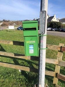
Post Box: There is a post box in this townland - close to the Skibbereen Eagle bar
The Historic Environment Viewer maps a ringfort and a souterrain that are not mentioned above.
Interesting Placenames
Besides the places named above we have mapped the follow field-names in this townland: Cúilín na Clover (small clover field - there are buildings there now), Páirc a' Locha (field of the lake which is close by - alternative is Páirc a' Leaca (sloping field)), Páirc an tSagairt (priest's field), Coimín Beag (perhaps the small hollow), Banc (probably a gaelicised version for bank/earthen bank), Garaoin (perhaps garraí-ín as in small potato garden - there are buildings there now)
There are also a number of coastal features in this townland as follows: Gearóids (Conor to check), Tobar bay - Trá na gCloch (Conor to check), Gírán (Conor to check), Fiall Aird (Conor to check), An Cúl Tráigh (the back strand), Faill a' Tónacáin (faill is a cliff while tónacháin means to move on one's bottom - if correct the name probably comes from the art of collection eggs from sea bird nests), Cuas na Sruithí (meaning unknown - Lankford suggests Cuas n Sruthán - cove of streams), Illaungaune (angliisation of Oileán na gCuán - island of sea urchins)
If you want to see the actual location of any of these, go to detailed townland map on Open Street Maps. If you know any other field names or placenames in this townland (or if you need to correct any or give further background information), please contact us at [email protected]
Folklore
Tragumna by Michael Barry (Ballyalla)
I know a spot of beauty rare.
Where Nature's charms are truly seen,
And sweetest perfume scents the air,
All wafted o'er the meadows green:
How sweet to ramble by its shore
When sunset lights each sparkling spray,
And evening shadows linger o’er
The waters of Tragumna Bay.”
The March to Bawneshall: Michael Barry also wrote a song about a battle of sorts: a football match between his beloved Lough Rovers (representing the area between Lough Hyne and Tragumna) and a team from Toe Head. This match was played for many years on Saint Stephen’s Day in Sweeney’s field in Farranconnor (opposite Dooneen School). This game was sporting and Lough Rovers were the victors this time round.
(first printed in the Southern Star on March 25th 1916)
The March to Bawneshall- final verse
Now farewell to lovely Tralegagh
And Lahern tower also,
But hurrah for fair Tragumna,
Where the apple praties grow.
Farewell to old Bawneshal,
The crossroads by the sea,
Long live the men of Munster,
The gallant and the free.
Burials in Bawnlahan: The story comes from the Schools Folklore of 1938.
In the townland of "Gleann na gCill." in the parish of Castlehaven, Barony of West Carbery, there is still to be seen a gollán called gollán an óir. But Tragumna was not unique in the internment of money. Many ‘gadaí’ or thieves in the parish never revealed the location as they had expired. In fact a neighbouring townland are still searching for ‘an gadaí dubh’
One story relates that a giant in olden times buried a crock of gold beneath this stone where it still lies buried.
Another story relates that pirates were chased into Tragumna Bay where they came ashore and buried two large boots filled with gold. It is said that one boot was found by a man named Sweeny, while the other boot with its treasure was never found. The common belief is that this boot is buried under "Gollán an óir."
Families and Notable Residents
The Tithe Applotment books of 1825 list the following family names: Dwyer, Sullivan, Woods, Duseale, Collins, Duseale, Duseale, Carthy.
Griffiths Valuation of 1853 lists the following family names: Sullivan, Murphy, Woods, Dwyer, McCarthy, McCarthy, Sullivan, Sullivan, Dwyer, Dwyer, Dwyer, Hurley.
The Census of Ireland of 1901 lists the following family names: Driscoll (with Connor (servant)), Burchill, Driscoll (with McCarthy (boarder) and Sullivan (boarder)), Dwyer, Dwyer, Hurley (with Donovan (servant)), Casey, Sullivan, McCarthy, Murphy, Maguire (with MacCarthy (mother-in-law)).
The Census of Ireland of 1911 lists the following family names: Maguire, Driscoll (with Connor (servant)), Driscoll (with McCarthy (boarder) and Sullivan (nephew)), Hurley, Sullivan, McCarthy, Murphy, Dwyer, Dwyer, Burchill.
Note: the term 'with' refers to a person or persons of a different family name staying in the house. This may have been an in-law or other relative, a guest, or a farm labourer/housekeeper or domestic servant.
Demographics and Landholding
| *Occupiers | Population | Change | Link to record | ||
| 1825 | Tithe Applotment | 8 (in 4 pairs) | 45 est. | 1825 | |
| 1841 | Census of Ireland | 18 | 104 | ||
| 1851 | Census of Ireland |
13 |
78 | ||
| 1853 | Griffith's Valuation | 12 | 70 est | 1853 | |
| 1861 | Census of Ireland | 14 | 78 | ||
| 1871 | Census of Ireland | 18 | 90 | ||
| 1881 | Census of Ireland | 14 | 79 | ||
| 1891 | Census of Ireland | 15 (inc. 1 unoccupied) | 73 | ||
| 1901 | Census of Ireland | 12 (inc 1 unoccupied) | 50 | 1901 | |
| 1911 | Census of Ireland | 11 (inc 1 unoccupied) | 40 | 1911 |
*Occupiers generally equate to households having a house and land but may also include households having houses but no land.
Between 1656 and 1658 the Down Survey mapped all areas of the country to track ownership of land after much had been granted to followers of Cromwell after the war of the 1650's. The most prominent proprietors (titulado) of this townland at that time was Finyne Mc Dermod, Driscoll & Donogh O'Driscoll, also Carragh. This townland was part of Rinecormack and Banelahan at that time.
The landlord in 1841 was Rev. Michael Becher of Mallow and the agent was John Connelly of Ardgehane. It was all held under lease by Thomas Somerville of Drishane and sub-let to tenants without a lease.
In 1841, the soil was described as being a great part coarse and rocky and half arable pasture mixed with parts of poor arable, producing light crops of wheat, oats, barley and potatoes.
Images
Local Business & Services
| Name |
Skibbereen Eagle |
| Description |
This busy bar and restaurant opened in July 1976. Food today is provided ny Elysium Catering |
| Contact |
Skibbereen Eagle Facebook Page Tel: +353 (0)28 22148
Elysium Catering Facebook Page Tel: +353 (0)86 0608033
|
|
Name |
Beach |
| Description |
There is a blue-flag at Tragumna and it is staffed by lifeguards over the summer months> there are also toilet and changing facilities available |
| Contact |
|
|
Name |
Defibrillator |
| Description |
There is a defibrillator located in the field just behind the re-cycling bins |
| Contact |
|
|
Name |
Recycling |
| Description |
There are recycling bins opposite the sea wall in Tragumna. These provide re-cycling for cans and bottles |
| Contact |
|
Further Reading
-
Parish Histories and Placenames of West Cork - Bruno O'Donoghue
-
Placenames Database of Ireland Logainm.ie entry for statutory version in Irish and English
-
A Collection Of Placenames From Cork County, Barony Of West Carbery (East Div.),Volume 2 - Dr Éamon Lankford
- Castlehaven & Myross History Society Journal Vol. 1 - 2020
- Castlehaven & Myross History Society Journal Vol. 2 - 2021
- Castlehaven & Myross History Society Journal Vol. 3 - 2022: Tragumna (Vincent O'Neill) Pg 49
- Skibbereen and District Historical Society Journal Vol. 7 - Placenames Based on the Irish Words for Fields and Land Divisions (Eugene Daly) Pg. 15/16
- Parish Histories and Place Names of West Cork - Bruno O'Donoghue
- See townlands.ie for information on this townland
Links
Go to Homepage
Go to list of Townlands
Go to list of Irish words used locally
Go to local Flora and Fauna

 Tragumna Pipe Band